Click Image to Enlarge
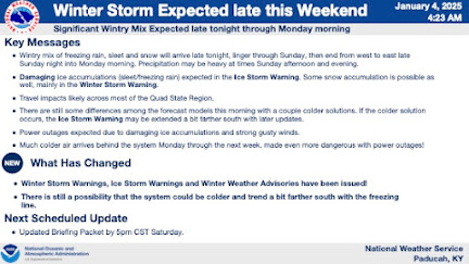
The National Weather Service has issued an urgent winter storm forecast starting late tonight, January 4. Here's what local residents need to know about the incoming storm and its potential impacts:
What to Expect
- Timing:
- The storm will start between 10 PM and 1 AM tonight, spreading from west to east. It will continue through Sunday night, tapering off as light snow into early Monday morning.
- Precipitation Types:
- A mix of freezing rain, sleet, and snow is expected to blanket the region. Freezing rain may transition to rain in the southern counties during the early hours of Sunday, but sleet and snow will persist elsewhere.
- Hazards:
- Damaging ice accumulations are likely, particularly in areas under Ice Storm Warnings. Snowfall is also anticipated in regions with Winter Storm Warnings.
- Widespread power outages are expected, coupled with gusty winds and dangerously cold temperatures following the storm.
Impacts on Travel and Safety
- Travel Conditions:
- Hazardous road conditions are likely throughout the weekend. Heavy precipitation and slick surfaces may make driving treacherous.
- Power Outages:
- With significant ice accumulation and strong winds, power outages are expected across affected areas. Residents should prepare for extended outages by stocking up on essentials.
- Post-Storm Arctic Chill:
- Beginning Monday, temperatures are forecasted to drop significantly, with wind chills plunging into single digits or below zero. This could exacerbate challenges caused by power outages.
Preparation Tips
- Stock Up: Ensure you have enough food, water, and medications to last several days.
- Stay Warm: Prepare alternative heating methods in case of power loss and keep extra blankets handy.
- Protect Your Home: Insulate exposed pipes to prevent freezing, and have sand or salt ready to treat icy walkways.
- Travel Caution: Avoid unnecessary travel. If you must drive, carry an emergency kit and check road conditions.
Looking Ahead
The storm's effects will linger into Monday morning, with precipitation ending as light snow. However, the arctic cold that follows will be a major concern, particularly for areas experiencing power outages. The National Weather Service advises continued monitoring of updates as small shifts in the storm's path could affect precipitation types and accumulations.
Stay safe and prepare now for this significant winter event. For the latest updates, visit weather.gov/pah/winter.


No comments:
Post a Comment